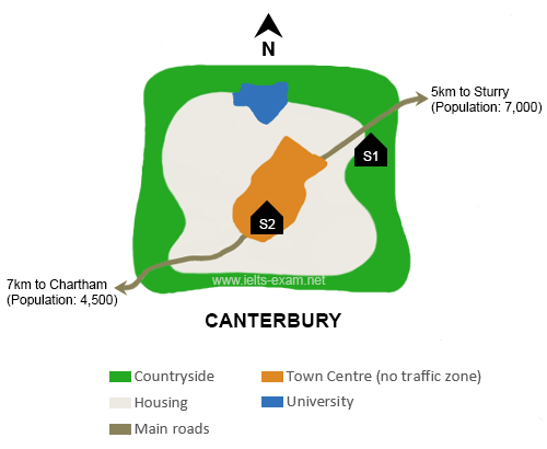
IELTS Essay on School Construction IELTS Essay on School Construction Task 1 Read and respond to the following task. You should spend about 20 minutes on this task. Write at least 150 words. The map below is of the town of Canterbury. A new school indicated as (S) is planned for the area. The map displays two possible sites for the school construction. Summarise the information by selecting and reporting the main features, and make comparisons where relevant. Source of visual data: https://www.ielts-exam.net/ As you see in the map, there are two possible locations for the school. These locations are displayed with black pentagons labeled with ...
Home » IELTS Essay Writing Practice » IELTS Essay on School Construction Task 1 with Analysis

IELTS Essay on School Construction Task 1 with Analysis
Updated: by Dr. Mohammad Hossein Hariri Asl
Time to Read: 2 minutes | 317 Views | 4 Comments on IELTS Essay on School Construction Task 1 with Analysis
Share This Post
About the Author
Dr. Mohammad Hossein Hariri Asl is an English and Persian instructor, educator, researcher, inventor, published author, blogger, SEO expert, website developer, entrepreneur, and the creator of LELB Society. He's got a PhD in TEFL (Teaching English as a Foreign Language).
Number of Posts: 4242


The map shows two possible locations for the new school as S1 and S2 in Canterbury with surrounding area. Both have the same distance of university located in north of Canterbury.
As you see, S1 located in east-north of the Canterbury. It has near location for student that live in Sturry. So that, it is suitable for these students coming from Sturry. It is outside of the housing area and situated in the countryside. It is 7 km far from the Chartham.
In contrast, S2 located in town Centre without traffic zone. It is easy for student coming from Sturry, Chartham, housing area and town Centre to reach the school.
Thank you for your report. It will be analyzed profoundly.
As you see in the map, there are two possible locations for the school. These locations are displayed with black pentagons labeled with S1 and S2. The site S1 is located at the East edge of the map and in the countryside. The second location, that is s2, is approximately in the middle of the map and in the south of the town canter. This site is 5 km far from the Sturry and 7 km far from the Chartham.
In comparison site S2 has one strength point. S2 is in town center and is surrounded by housing area. It means that it will probably embrace more student, because more people live in this area. The weak point of S2 is being located in no traffic zone. So, people have limitation in using their cars in this area. From this point of view S1 is more accessible for students and their parents.
Thanks for submitting your report to us for deep analysis.